GPS Connection
Where the device supports a GPS facility HighLight may be set to use this information:
-
Specific location logging triggered by the user to identify the current location.Specific location logging triggered by the user to identify the current location.
-
Real time logging of current location on both Drive Through and Walking Surveys.Real time logging of current location on both Drive Through and Walking Surveys.
Background logging of location throughout a shift/day - typically recording the point at 100m distance / 5 minute intervals (whichever the sooner).Background logging of location throughout a shift/day - typically recording the point at 100m distance / 5 minute intervals (whichever the sooner).
To activate the GPS the communications port (COM Port) and connection speed (Baud rate) must be specified in the HighLight configuration file [HighLight.ini]. Typical settings for these two entries are:
[HighField]
GPSCommPortNo=2
GPSCommBaudRate=9600
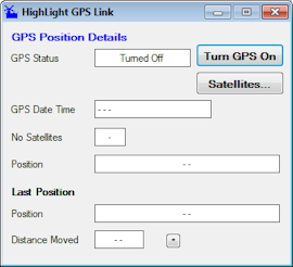
HighLight includes a GPS command button that should be used to open the GPS control panel and activate the GPS device. This control panel should left open throughout the entire HighLight session to ensure GPS locations are logged. HighLight will prompt to start the GPS if it is not already active when entering key display panels.

This control panel (shown above before the GPS has been turned 'On') shows the location in Longitude / Latitude only. The GPS also logs details on location Height above sea level (not particularly accurate - or useful), travelling direction and speed. The panel also offers a link to a GPS Satellites…which may be used to search for the GPS connection details if not known.
HighLight will convert GPS Longitude / Latitude to OS Grid references (Easting / Northing) if the relevant Coordinate Conversion details have been loaded in the current HighLight Database held on the device (Grid Reference conversion is given only when the user has opened as current database file). Generally highlight is loaded with coordinate data relevant to the host Contract Area - and will not operate outside this defined area.
Resolution of Grid reference to the Contract Network model (Chart Section and Distance) is provided where the necessary definitions are included within the Chart Section header details. The accuracy of the conversion depends on the level and accuracy of these source details.
HighLight applies all GPS conversions to maximum arithmetic accuracy (double precision functions) following definitions laid out by the Ordnance Survey. Grids Reference locations are displayed and saved in whole metre increments only.
Where a device has no GPS capability HighLight can still be used for all data collection, Location details will have to be provided by the User through other means: external GPS device, network marker posts, node points and survey wheel etc.
Note: If HighLight is running and using the GPS for recording the current location other applications may NOT be able to read the GPS settings at the same time.
It is essential that once a configuration has been set up other applications / configurations do not reallocate the GPS communications settings.
HighLight uses the ZylGPSReceiver.dll utility library (from Zyl Soft, .Net version, Build version 2).